
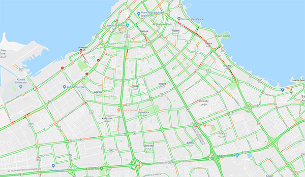
Later today some parts of highway 50 and the 5th ring road will be closing down due to the GCC Summit. There are expectations that the closures will result in traffic chaos, but as of 9AM, there seems to be less traffic than usual. This will probably change once the roads close down at noon, but not a bad start to the day.
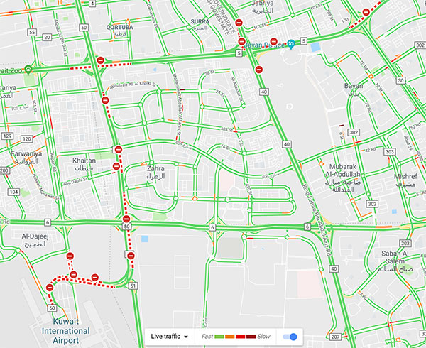
Update: A reader made me realize that at 12PM Google updated the map of Kuwait to highlight the closed roads. Impressive.
14 replies on “GCC Summit Traffic Situation”
Hi Mark, most of the schools have been closed for today to reduce traffic so hopefully the roads will be good during the closures.
Always wondered why choppers aren’t used to ferry VIPs. Could spare some of the disruption.
Because they don’t come alone, the come with an army of servants.
WOW check it now. At exactly 12:00 Google Maps shows road closures in all the right areas. MOI must have coordinated with Google, which is astounding!
It’s also worth mentioning that in general, if the road is temporarily closed for any reason, it will show as green since there are no cars to return traffic data to Google.
Google shows green if there isn’t traffic, open road or closed. What you need to keep an eye out for is the red
You all missed my point. Google is showing road closures ⛔️ Not just traffic conditions. It came into effect at noon exactly, which is why I think the MOI coordinated with Google on this.
I didn’t miss your point nor did Kuwait, me and him are discussing a different subject not related to your comment.
Yes, that’s what I’m saying. The other day when erdogan came and they closed King Fahad, it showed green and I was thinking wow, no traffic today.
yeah but if roads are closed, other roads leading to that one will be red because of traffic, thats why i’m saying u got to keep your eye on the red not the green
Road closures and accidents are fed to Google Maps through Waze, a navigation rival company Google bought out in 2013. Waze has a number of nifty features that Google Maps lacks like reporting accidents, roadkill, potholes, road closures, broken-down cars, etc.
You can also create new roads. This is a particularly good feature especially if you drive around the areas currently under construction, since Google Maps takes a while to update their map.
I’d recommend everyone to try it out. Since its a community-feedback based app, the more the people use it, the more accurate Kuwait’s map becomes.
Will try it, thanks..
Very welcome
All that fuss for a 20 min meeting? Couldn’t they Skype it off?!
lol.