
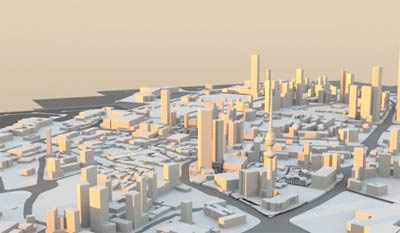
A Kuwaiti architect called Omar Al-Rajhi decided to start a new hobby after graduating from Kuwait University. He decided to recreate Kuwait City in 3D bit by bit. So far he has already has gone ahead and created 3D models of some of the most famous buildings which you can see on the projects FaceBook page.
It’s a painstakingly slow task and he currently doesn’t know what this could be used for once he’s done (maybe commercial or educational purposes) but for now he’s focusing on remodeling the whole of Kuwait City and once he’s done he’ll see what he can do with this data he is creating. Personally I think this could probably mean we could finally get 3D navigation like some of the main cities in the US. Here is the link to his projects Facebook page [Link]
36 replies on “Kuwait 3D Project”
Google people can do this in less than a week… with even more accurate details ;/
You are right, but this is not Google and they wont do it because of our Petrol, Google Done this only in few places and one of them is New York…
What does petrol got to do with anything? They’ve allowed you to see NewYork because they had to demo their technology.. they have already done this for most parts of the world. And they will do it here when there becomes need for it.
No, these models you see on google are done by normal people not google.
Google “people”.
Google is a corporation, this is one guy.
^^ What he said.
So what? What is the point of reinventing the wheel? What is the point of modeling a city one building at a time if there is the technology that can do it automatically and to the finest details and provide enough data that can be used in many ways more than we can probably ever imagine?
reading those comments, I feel like I’m missing something… but I can’t just see it! heh.
the point is that the people with the technology aren’t doing it so the guy is doing it himself.
You think there’s technology that automatically renders buildings into a 3D model? You are missing something.
No one is reinventing anything. The guy just wanted to make a 3D model and it was a pretty cool thing.
Why is everyone here a downer on everything in Kuwait?? :/
Because Kuwaiti’s are just supposed to be lazy and shouldn’t really try to acquire any new skills.
(this is sarcasm for anyone who can’t sense it)
wow these models can be seen very realistic in flight simulator
will not work! they need to completely remodeled for flight simulator. else you will frame rates less than 10 or crash. for fs, you can not make high detailed models as these.
Maybe, he can upload to google map database because only few buildings are there in street view.
I feel he will earn lots of money 😉
recognise the Marriott anyday.. will he re-create the empty lots in 3D as well – realistic rubble?
He can upload them to Google Earth!
No google can’t. People upload models they make in sketchup on google earth. The models are very important for architects to do urban studies and help them creating / designing urban centres. I was going to upload each building our architecture firm made throughout the GCC but I’m still changing them from max to sketchup.
You are talking about one thing and I’m talking about another…
You’re talking about individual buildings that some people do in sketchup and add on google earth. I’m talking about Google technology that uses data collected via street view vehicles to automatically generate 3d buildings.
This technology is already fully developed, already being implemented, and already has customers and existing market.
Creating a 3d animation of buildins isn’t that big deal, all you have to do is extrude a square in a graphics software and you get a highrise.. the big deal is with modeling whole cities.. and not just a ‘look alike’ city but exact measurements up to the metre.
So this guy should quit doing this because a corporation can do it better? How is that logical? This guy will probably gain a lot of knowledge and skill doing this, it’ll be something he can add to his CV/Resume/Portfolio and it’s something impressive.
If people thought like you, we wouldn’t have artists or people with any skill, because they’d automatically quit before they even start.
reminds me of this commercial https://www.youtube.com/watch?v=xATWg8Zlsrk
Just because someone did something already, doesn’t mean that no one else should do it anymore. If people thought the same way you do after the wheel was invented, we’ll probably still be using stone wheels till this very day…..
Very cool. Would be a good idea to keep a year by year model update to see the changes in Kuwait’s skyline. There’s quite a few new sky scrapers now compared to just a few years ago. Who knows how much will change in 10, 20 or 30 years time.
GTA Kuwait city
ohh yaa !
GTA Kuwait City 😉 !
i will end up jumping from Telecommunication tower top 😉 !
just call Google …
The effort alone is great, and the process seems great for one guy. and he might expand to speed up the process. besides, google wouldn’t know kuwait better than the locals. keep up the good work!
FYI this is how 3D navigation looks like https://www.flickr.com/photos/25926011@N02/5289152715/
speaking from an architectural point of view …the guy is doing a great job since he is taking care of all the building and even if it takes a long time, knowing he is doing it individually means it will be available for architects creating their projects in kuwait city in different formats giving them the ease of use in the 3d and 2d rendering and even models …which is something u dont get commercially …
thanks omar whatever ur purpose is 🙂
Thank you Mark for posting about the project, also I highly appreciate the comments (the positive and the negative ones).
My concerns for the right moment is to finish the project, and nothing else, specially people like 3azeez.
It would help me a lot if you provide me with more suggestions for the project
I kinda like the GTA Kuwait idea 😀
It would be cool once you’re done if we could explore a 3D Kuwait, navigate through the 3D render, not necessarily in a vehicle or by having a character walk around. Just “float” through it.
I would find it interesting, especially to observe some of the buildings at different angles.
That’s pretty cool! He could probably make a deal with Google by the time he’s done with it .. as mentioned..
i believe the process used for similar projects is called photogrammetric technology.. the models can be used for a variety of digital applications and can also be cnc milled to produce 3d physical models. on an urban scale these are very useful for architects and planners to visualise new developments and give accurate depictions of sun studies and contextual renderings. i would encourage omar to continue with this project as it will surely contribute to future developments in kuwait when finished to a higher level of detail. great work!
this is a link to a company specialising in this technology here in the uk :
https://www.cityvisionnetworks.co.uk
Why is he doing this on a closed system when he can use an open system like google earth! In google everyone can participate even non architects and the city gets populated very rapidly once a few people start to populate a city!
It’s very easy, I myself got one building in kuwait accept by google and it is now officially showing in google earth’s 3d bldg layer. I used free software (Sketchup).
I think he should convert what he’s done so far to sketchup and submit it to google, and invite everyone in and out of Kuwait to participate, it can be done in less than one year.
Because he doing it for himself, not doing it to be part of anything or anyone else.
What’s the point! That makes the effort really a waste!!!
And what do you suggest he do in his spare time? Sip some coffee at the Starbucks in Avenues while watching people walk around in the mall? *rolleyes*