
40 years ago, NASA’s Landsat program launched it’s initial satellite into space (July 23, 1972). Since then the program has been tracking and recording changes on the Earth’s surface via satellite imagery.
Since it’s been 40 years, NASA commemorated the anniversary by selecting and compiling a list of its top ten stories or revealing images which it had stored up during its four decades of existence. One of the stories that made the top 10 was the 1991 Kuwait Oil Fires.

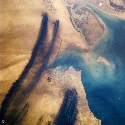
As Iraqi troops withdrew from Kuwait at the end of the first Gulf War, they set fire to over 650 oil wells and damaged many more, just south of the Iraq border (yellow line). These Landsat images show before, during and after the release of 1.5 billion barrels of oil into the environment, the largest oil spill in human history.
You can check out the top 10 stories and images on [WIRED]
One reply on “Kuwait Oil Fires, 1991”
this consequently is brought up approximately the same time as sahar al lail did that whole ’91 war scene.