
I know a lot of people will be traveling to Europe during the Eid so I just wanted to share some handy travel software that will work on Nokia phones and in some cases other smartphones, iPods and PDA’s.
I already previously posted about A-Z Maps which I purchased before I traveled to London for the first time last month. It was an incredibly easy to use software which allowed me to navigate London very easily as if I had been there before. The company has maps for other cities also including Paris, Barcelona and Helsinki. The map starts up instantly when you run it and then you just type the name of the street you are in and the software will show you where you are on the map. It’s also not expensive costing around KD10. More details on this software is available on the publishers website. https://www.lumisoft.net/
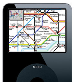
Another software I recently purchased in my preparation for my London trip later this month is Tube 2. When I was in Paris last month I had a hard time navigating the underground subway system and this software will be making my life a lot easier this time around. I purchased two versions of the software, the Tube 2 London and Tube 2 Paris. How it works is you type the name of the station you are in and then type the name of the station you want to go to and the software will visually show you your route on the underground map AND it will also give you step by step instructions. Here is an example of a trip from the Marble Arch to Waterloo station:
Marble Arch to Waterloo
Time: 13 minutes
Changes: 11. Marble Arch to Bond Street
Depart Marble Arch via the Central line (Eastbound) towards Epping for 1 stop.
Service runs every 5 minutes.2. Bond Street to Waterloo
At Bond Street change to the Jubilee line (Southbound) towards Stratford for 3 stops.
Service runs every 5 minutes.3. Waterloo
Arrive at Waterloo.
As you can see it makes things a lot easier. The software costs like KD3 and its available for the London, Paris and New York subway system. You can get more information from the software publishers website. They also have versions that work on iPods but they work differently. https://visualit.co.uk/
8 replies on “Travel Software”
Nice software tip Mark. Thanks.
Planning on travelling to Toronto and was looking for something similar.
What about Nokia N95? Would that be as effective?, especially with it’s built-in GPS?
The softwares above dont use GPS but if you do have GPS i am sure there are more interactive options available.
if you need software to figure out the tube system in london, new york, or paris, you shouldn’t be travelin in the first place..
the underground system and trails are as complex as 3rd grade mathematics.. i mean, the lines are even all colored in too!
this is a perfect example of unnecessary software that overcomplicates common sense.
I don’t know if you ever used a subway before but if you try to go from one place to another it involves a lot of map checking to make sure you are going the right direction and to figure out where to get off and what subway to take next so you could get to your final stop. This software simplifies the process.
u dont need software Mark, u get that map for free in an underground station in London.
No duh, the map is plastered on the walls also. Did you even read my post?
if you go onto the london transport web site
https://www.tfl.gov.uk/
and use their journey planner facility
https://journeyplanner.tfl.gov.uk/user/XSLT_TRIP_REQUEST2?language=en
it will give you a detailed route to get from one place to another using a variety of methods and you can print maps to help you as well if walking is one of the components.