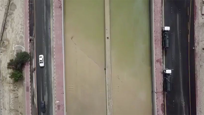
A friend sent me the drone footage above of the Fahaheel Expressway flooded in Mangaf. The highway is completely submerged underwater and looks like a river. It’s supposed to rain worse tonight… [YouTube]
Thanks XBS
 2:48AM - Entertaining Kuwait since 2003
A friend sent me the drone footage above of the Fahaheel Expressway flooded in Mangaf. The highway is completely submerged underwater and looks like a river. It’s supposed to rain worse tonight… [YouTube]
Thanks XBS
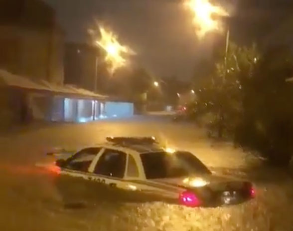
I was on the Kuwait sub on reddit and people were talking about the floods in Kuwait. I had no idea what they were talking about since I’ve been home all day so I popped open @kuwaitup2date and turns out Fahaheel got flooded earlier this evening from the rain. No idea how it happened but it’s horrible, it’s a legit flood.
They’re saying the weather is going to get worse so I decided not to risk it and moved my Lotus to a multistory lot next to my house so it would be parked a floor above ground. Although my building’s basement has never flooded, after watching the videos from Fahaheel I’m not risking it.
If you’re curious to know what has been happening in Fahaheel, check out @kuwaitup2date since he’s been posting a lot of videos.
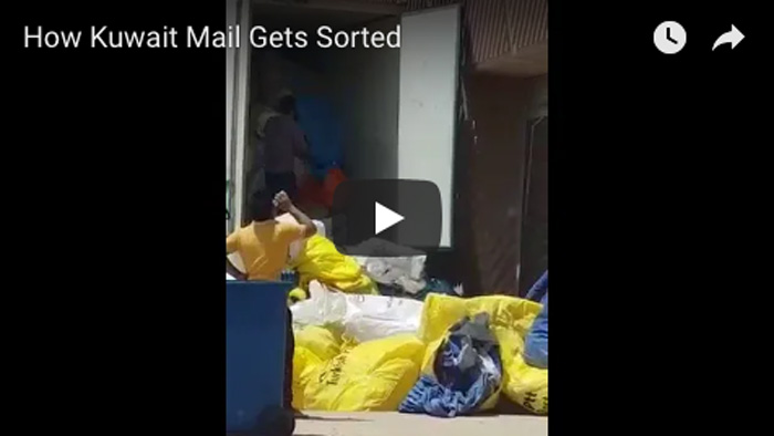
Although Kuwait mail has improved over the past few years it still needs a ton of work. Imagine how great online shopping would be if we had a mail system that wasn’t so archaic. [YouTube]
Thanks K

Not to be confused with the metro project, the rail project is designed to connect Kuwait with the rest of the GCC via rail. Once the project is completed you’ll be able to take the train from Kuwait City all the way to Oman. The first phase of the project will connect Kuwait City to Dammam in Saudi Arabia.
Although there is no relationship between the two, I’m sure everyone here would rather they began work on the far more interesting and useful metro project (pictured on top). [Link]

Back in October, an English school got a lot of heat when they refused to hire a teacher unless she took her hijab off. You would think other schools would have learned from that incident but doesn’t look like that happened.

The blog Life in Kuwait just posted a number of screenshots of a conversation she had with a school in Kuwait she was applying to that kept highlighting the fact that if she wanted to work there, she shouldn’t wear a hijab.
I can’t get over how bizarre it is for a school in Kuwait to make such a request. Check out the whole conversation on the Life in Kuwait blog [Here]
BBC posted a short video (watch above) on a team of European and Arab women who are trekking to the North Pole. One of the woman taking part in this trek is Lamees Nijem, a Kuwaiti who applied to be part of this adventure and got accepted. To prepare for the trip Lamees went on three training trips, one in Oman and two in Iceland. The trainings covered the basics of cross-country skiing, pulling sleds, sharing a tent with 3 other people and dealing with cold weather and extreme climate conditions such as snowstorms and very low temperature.
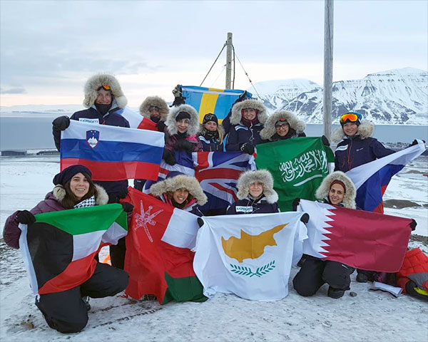
The main purpose of this expedition is to foster greater dialogue and understanding between women from Western and Arabian cultures. The team consists of 11 women that represent the countries of Saudi Arabia, Sweden, Cyprus, Kuwait, France, Oman, Qatar, Slovenia, Russia and the UK. For more information you can check out the expedition web site [Here] or follow them on instagram @northpole2018
The Kuwait Investment Forum (KIF2018) took place last week and on that occasion, they released the promo video above which showcases Kuwait while also containing information on the different upcoming projects and investment opportunities that are available. Looks like its full speed ahead for Kuwait 2035. [YouTube]
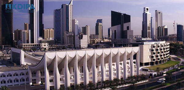
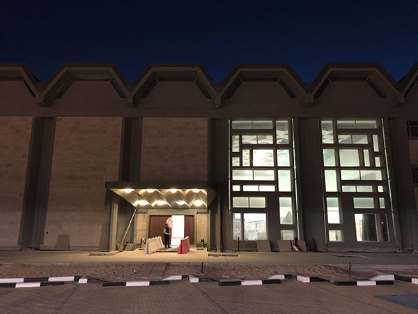
Yesterday I was invited to the Abdullah Al-Salem Cultural Centre (ASCC) for a conference and tour of all the museums. The event was meant to start at 5PM but I decided to get there half an hour early. When I got arrived I realized I was one of the first people there since the parking lot was fairly empty. So I decided to walk around the museums and explore.
For those of you who asked if the museums had enough parking, they do. There is a decently sized lot on the ground floor and another much larger lot in the basement.
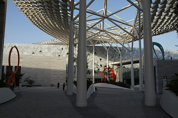
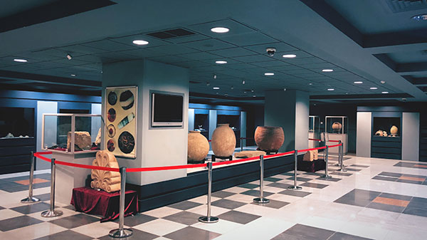
The museum grounds is pretty huge and involves quite a lot of walking. It took me around 30 minutes to walk around outside the museums before I decided to head back to the first building where the conference was going to take place. When I got there I realized people were just starting to show up and that no way the conference was starting on time. So I decided to ditch the event and instead go back to exploring the insides of the museums. That turned out to be the best idea because I ended up having the all the museum just for myself and I have to say, the place is amazing!

There are four museums occupying six main buildings:
– Natural History Museum
– Science & Technology Museum
– Arabic Islamic Science Museum
– Space Museum


I literally was running around trying to capture photos for my instagram before it started getting dark and it took me over an hour and a half to run through the whole museum. I didn’t even stop to read a plaque, interact with an exhibit or walk around every hall properly and it took me that long, so imagine how long it will take you to explore the exhibits fully. I was told you’d need around 6 hours per museum and that doesn’t include attending any of the shows or workshops that are going to be held there frequently.

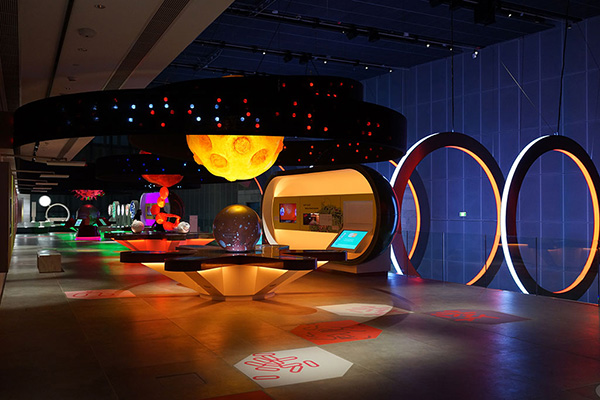
From all the exhibits I think my favorite might be the Human Body building of the Science & Technolgy Museum. Although I had left it until the end because I thought it was going to be lame, I think it’s probably one of the most fun and interactive areas. For example, they have a 15m running track where you could run and it would calculate your time and then compare it to famous people including record holder Usain Bolt. So you know I’m definitely going to go back in my full sports gear just to try that out. The whole lower section of that building was filled with different sports activities for you to try, interact or play around with. Then upstairs you have one of the visually most colorful and exciting looking exhibits that deals with viruses (pictured below), and there was also a biology lab where they’ll be holding workshops for people of all ages. That’s another thing I really liked about the museums, not only were their exhibits but in each museum, there were also classrooms and spaces to hold workshops.
The most surprising exhibit to me was probably the Ecosystems building under the Natural History Museum. I walked in and was mind blown, they had converted one of the buildings into an indoor rainforest with an active waterfall and water pools. I was not expecting that at all. You could walk around the rainforest from above it or from the ground floor. I started from the top since that’s where I came in from since I was at the dinosaurs exhibit next door, and then headed down. Once I was done on the ground floor I got another surprise, turns out the pools of water I had seen from the top were actually the top of the huge aquarium which was located in the basement. It’s a huge aquarium, I probably larger than the one at the Scientific Center although it wasn’t yet filled with a lot of fish.


I think I’m going to stop here since this post would end up being gigantic if I described every section of the museum. All you really need to know is that this is a legit and proper museum. I don’t know how they were able to build it and put it together in such a short period of time, and I am really impressed. The only negative thing might be in regards to the ticketing system. The museums were originally meant to be free but late into the project they decided to charge a nominal entry fee of KD3 for adults and KD2 for children. Since the building wasn’t built with the idea of ticketing in mind, they installed drive-thru ticket stations at the parking entrance. There are nine ticket stations in the parking area, you drive up to one, purchase tickets for every passenger in the car and then you’re allowed in. I can imagine that causing a lot of traffic to get in, especially in the beginning when people are rushing to see the museums. But, there is a side entrance for drop-offs and pedestrians, so if it does get super busy, I’ll just ride my bicycle down the street to the museum or have a cab drop me off.
If you want to know more about the museum including location, ticket prices, opening hours, you name it, then check out the ASCC website which is really thorough [Here]

The Sheikh Abdullah Al-Salem Cultural Centre museums is officially opening tomorrow and their website is now live and contains their ticket prices, opening hours and floor maps of the place amongst other information. The ticket prices turned out to be super reasonable with children under 18 costing KD2 and adults costing KD3. Here all the ticket prices:
Adults (18+): 3 KD
Junior | Student (Max 18): 2 KD
Under 2: Free of Charge
Ambulant Disabled: 1.5 KD
Wheelchair Disabled: 1.5 KD + Free Helper
Chaperon: 2 KD
Below is the map of the museum so you can see all the buildings and what they contain.

Opening hours are 9AM to 9PM on weekdays, and 3PM to 11PM on weekends. They’re closed on Sundays.

I’m actually headed to the museums in a bit since I’ve been invited to the pre-opening and I’m super excited. Hopefully, they’ll let me take photos so that I can post them up here tomorrow. To check out their website, visit ascckw.com
Update: They’ve changed their opening hours and I’ve updated the post to reflect that

The Sheikh Abdullah Al-Salem Cultural Centre (ASCC) will officially be opening to the public next week on Wednesday, March 14th. The cultural center houses a Space Museum, Science Museum, Natural History Museum and an Islamic Museum so I’m super excited to check it out.
To stay posted you can follow them on instagram @ascc_kw
Hyperlapse is a technique in time-lapse photography that allows the photographer to create motion shots. The hyperlapse video above was shot by Sayed Husain Alhashemi and then edited by Abdulrazzaq Alsrayea, it took them 6 months of shooting and an additional 30 hours of editing to put it all together. Some of the scenes are pretty incredible so check out the video above or on [YouTube]
Back in September, they announced that part of Salem Al Mubarak Street was going to be turned into pedestrian only. I took the video above this morning right outside my apartment building to show you the current status, and as you can see the project has progressed considerably since my last post on the street.
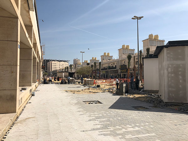
My biggest issue with the project was that they had killed 25 trees on that street that had been there for over 50 years. They’ve now planted new palm trees instead which although is a nice gesture, palm trees just don’t offer any shade and can’t house as many birds as the older trees did. I really wished they had managed to keep those older trees.

In any case, the street is starting to shape up and I think they’re trying to have everything done by February 25th which right now seems unattainable.
But, a new issue is starting to pop up and that is gentrification. Because the street is getting fixed up, the value of real estate around it is also going up. My rent was already slightly increased since my building is suddenly now in a prime location, people are also now bidding on the empty stores in my building which previously nobody wanted. I’d really really hate it if my apartment rent goes up to the point where I’ll be priced out and be forced to move.
On the bright side, they haven’t sorted the parking issue in the area. Parking in my neighborhood has always been historically terrible and now they’ve gone and removed all the parking spots on the main street without adding any new ones. With this street facelift, we’re now going to have even a higher influx of people come into the area than before, so the parking situation will be even worse which is kinda great for me. Hopefully this parking mess is going to help keep the popularity of the area down to a reasonable level, which in return should keep my rent at a reasonable level.
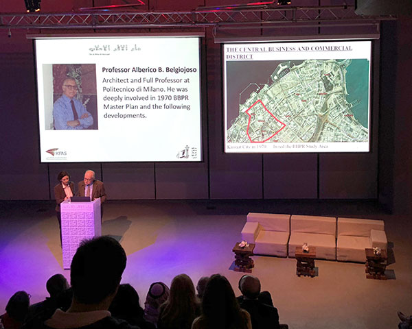
Over the weekend I went to the Modern Architecture Kuwait conference and attended a talk by Prof. Alberico B. Belgiojoso titled “The 1970 Vision for Kuwait City”. It was a pretty interesting talk and made me realize how young Kuwait City was.
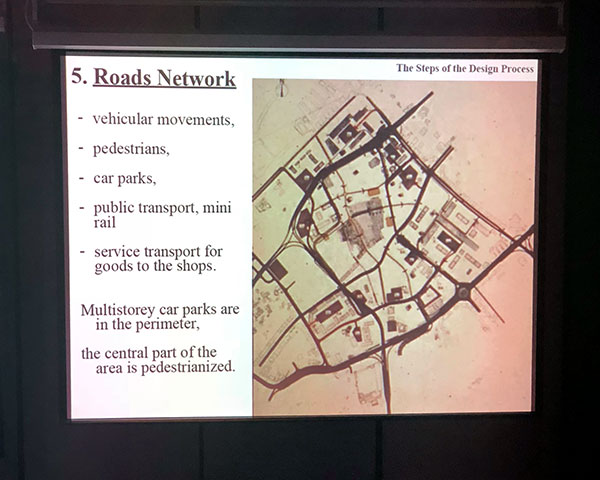
Prof. Alberico worked with the architectural firm BBPR back in the 60s on various proposals on how to bring Kuwait City into the modern era, into the city you see today. One of the interesting things he discussed was how the original master plan of the city, they proposed to build all these parking structures around the city included underground and overground passageways, shaded paths and even monorails that would connect parking structures to main areas and buildings. I’d imagine if we had any of those today, less people would be inclined to park illegally just to avoid walking long distances in the summer months.
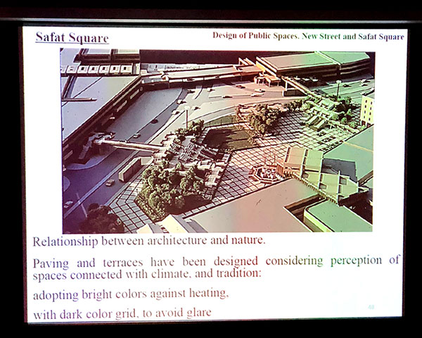
Prof. Alberico also shared the visual above on their proposal for Safat Square which looks a lot more accessible and visible compared to how the square looks today. I kinda wish someone would revisit the old plans for Kuwait and implement some of the cooler ideas from them.
I could swear I’ve written about the Heritage Museum before but I can’t seem to find the old post for some reason. The Heritage Museum is located inside the Kuwait National Museum and I passed by yesterday since I wanted to check and see if the Planetarium at the museum was still open. The Kuwait National Museum is currently being refurbished (I’m so glad they decided not to demolish it) so I wasn’t sure if visitors could still access it or not. Turns out, for the most part, its inaccessible including the Planetarium, but the Archaeology Exhibit and the Heritage Museum can still be accessed.
Archaeology Exhibit
I didn’t find this exhibit to be that interesting and it’s pretty small. It’s located right as you walk into the museum and it will take you just a few minutes to skim through the stuff on your way to the main Heritage Museum.
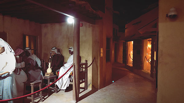
Heritage Museum
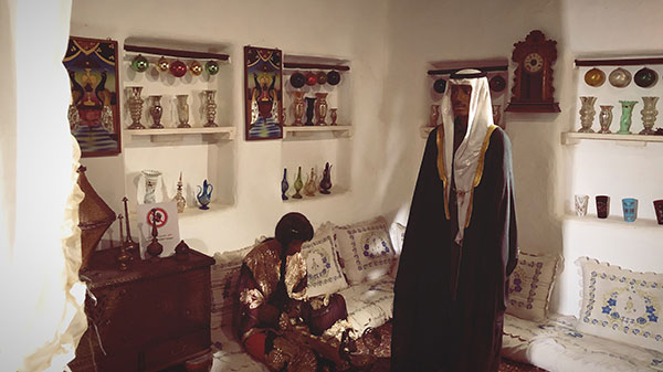
This part of the museum is a lot more interesting to check out and is fairly big which makes the trip worthwhile. The Heritage Museum is divided into three areas, the first is a wax museum where different aspects of Kuwait’s traditional past are on display. The wax models aren’t very realistic but there are a lot of different displays and the whole thing is meant to resemble an old Kuwaiti street so it’s at least visually interesting.

The second part of the Heritage Museum is where different items from Kuwait’s past are on display. These aren’t wax objects but actual real objects that were collected and put on display. An example of a display would be for example a collection of old radios that were used in Kuwait back in the old days.
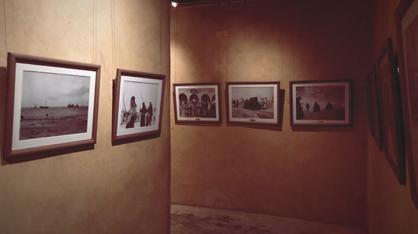
The final part of the Heritage Museum is a small photography exhibit where old photos of Kuwait are on display. This is a fairly small cooridor which you’ll be walking through on your way out of the exhibition and is fairly dark so it’s hard to see the photos properly.
If you’ve never been to the Heritage Museum you should check it out mostly because of how odd it is. I mean the eerie dark mood of the museum is alone worth the trip and with the construction taking place, it just adds to the whole creepy mood. If you want to pass by, the museum is open from 8AM to 2PM and then again from 4PM to 8PM. There is no entrance fee. Here is the location on [Google Maps]

Not only do we have an addiction treatment center in Kuwait, but its actually so good that addicts from other GCC countries come to Kuwait to get treated here. Recently through a friend, I managed to find out a lot about our treatment facility, and I was so impressed I decided I’d share what I learned.
If you have a drug problem, the first thing you need to do is admit yourself into the KFH Addiction Treatment Center in Shuwaikh [Map]. You go to the reception and you ask to see the doctor (they don’t admit on Fridays). The doctor will ask you a few questions including what substances you use and you will also be administered a drug test. After this first step is completed, you’ll be admitted.
As part of the admittance process you will be given a full body search to make sure you don’t have any drugs on you. You can check-in your belongings before admittance and you can also put money on your account in case during your stay you need to purchase something from the baqala like cigarettes since money isn’t allowed inside the center. Once you admit yourself into the center, you can’t leave for 21-28 days.
The treatment facility is for everyone including expats. Until recently, it was also free for everyone but with the new health fees, expats now have to pay a fee per day.
During your stay at the treatment center, doctors will check up on you often. There are also different workshops and lectures that take place there for example, there are lectures on recovery, lectures on how to deal with negative thoughts and lectures on judgment errors and what they are. In addition to the lectures, there are also group therapy sessions that take place. All the lectures are given by therapists with a few exceptions where doctors give the lectures themselves. Every Tuesday there are also sessions for family members called “Tawasal”. These sessions allow the parents to understand and cope with family members who are in there for treatment.
It is important to state here that your medical file with the treatment center is not shared with any other party and remains with the center. So your admittance won’t pop up when applying for a job or anything of the sort.
After around 21 to 28 days you’ll be able to check out of the center. They then highly recommend you stay in a halfway house which is a temporary living arrangement for people suffering addiction. The halfway houses are run by recovering addicts who are helping other addicts stay clean. Unlike the addiction center, there are no nurses or doctors here and you’re allowed to leave at any time you want. But, if you decide to become a resident at a halfway house, there are rules to abide by. There are rules like having to wake up early, having to clean your room, do some house chores and also signing in and out throughout the day. The rules meant to provide structure for the addicts who at this point don’t have any.

The halfway houses also provide group therapy sessions and are where the addicts are introduced to the 12 Steps of NA, the Narcotics Anonymous program. The program is essential to recovery once they leave, it becomes part of their lives and they keep at it after they leave the halfway house to stay clean. Even though you’re allowed to leave the halfway house anytime you want, the recommendation is that you work through the NA program. Part of the program is choosing a sponsor and attending external NA meetings. I attended a meeting with my friend as support and was completely taken away by it. I attended an English NA meeting and there were around 30 guys and girls from different age groups and backgrounds. It’s difficult to put into words what I felt, but it was very emotional. Once a week they meet up with other people who are going through the same things they are going through, even though most of them don’t know each other, they all still connect on a very personal level and I found that to be so beautiful.
Once you work your way through the NA steps and reach step 5, and you’ve got your external affairs in order, that is when it is recommended that you graduate from the halfway house. There is no specific timeframe to reach this step, some people have been able to do it in 3-4 months, others have taken 1 to 2 years. The average is around 1 year.
So that is basically it. I was so surprised at the quality of support addicts have here in Kuwait I really wanted to write about it. I think what surprised me the most is the understanding and sophistication involved from the government on this subject. I assumed because this is Kuwait, addicts would be treated like criminals and arrested, but instead, the government understands that addiction is a complex disease that can be treated. It’s instances like this that make me really appreciate Kuwait sometimes.